Boyle (barony)
Boyle
Mainistir na Búille (Irish) | |
|---|---|
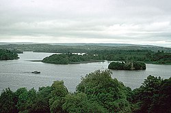
 View of Lough Key | |
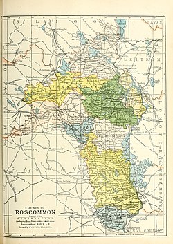
 Barony map of County Roscommon, 1900; Boyle is coloured pink, in the north. | |
| Sovereign state | Ireland |
| Province | Connacht |
| County | Roscommon |
| Area | |
| • Total | 328.46 km2 (126.82 sq mi) |
Boyle (Irish: Mainistir na Búille[1]) is a barony in the far north of County Roscommon in Ireland.[2][3]
Etymology
[edit]Boyle barony is named after Boyle town, itself named after Boyle Abbey, which is named after the Boyle River.
Geography
[edit]Boyle barony is located in the far north of County Roscommon, separated from County Sligo by Lough Gara, the Curlew Mountains and Lough Arrow, and separated from County Leitrim by Lough Allen and the River Shannon. It contains Lough Key.[4]
History
[edit]Boyle barony loosely corresponds to the ancient Gaelic kingdom of Magh Luirg an Dagda (Moylurg), the "plain of the tracks of Dagda."
In the 1585 Composition of Connacht, Boyle barony was confirmed as the possession of the Mac Diarmada, except for those parts which belonged to the Queen (then Elizabeth I) or the Church of Ireland.[5]
List of settlements
[edit]Below is a list of settlements in Boyle barony:
References
[edit]- ^ "Mainistir na Búille/Boyle". Logainm.ie.
- ^ "BOYLE, a corporate, market, and post-town, and a parish". www.libraryireland.com.
- ^ Weld (Isaac), Royal Dublin Society; Younger.), Isaac WELD (the (28 December 2018). "Statistical Survey of the County of Roscommon, drawn up under the direction of the Dublin Society. [With an appendix.]" – via Google Books.
- ^ Donlevy, Bryan (1 August 1792). "A map of Carrowreagh in the barony of Boyle and County of Roscommon as set by Arthur French. A scale of 40 perches to an inch. Surveyed in August 1792. By [illegible] Donleavy. Table of reference showing names of some tenants". catalogue.nli.ie.
- ^ "Perrot's Composition of the Barony of Boyle". www.irelandxo.com.


